Page 9 - 2021PSF-ResilientCoastsForSalmon-NewLogo-Primer-Web
P. 9

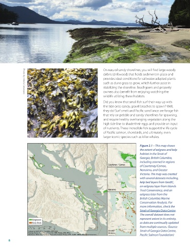
Photo by: Mitch Miller

                                                                    On natural sandy shorelines, you will find large woody
                                                                    debris (driftwood) that holds sediment in place and
                                                                    provides ideal conditions for saltwater-adapted plants
                                                                    such as dune grass to grow, which further assist in
                                                                    stabilizing the shoreline . Beachgoers and property
                                                                    owners also benefit from enjoying watching the
                                                                    wildlife utilizing these habitats .
                Photo by: Maria Catanzaro
                                                                    Did you know that small fish surf their way up with
                                                                    the tide onto sandy, gravel beaches to spawn? Well,
                                                                    they do! Surf smelt and Pacific sand lance are forage fish
                                                                    that rely on pebble and sandy shorelines for spawning,
                                                                    and require healthy overhanging vegetation along the
                                                                    high tide line to shade their eggs and provide an input
                                                                    of nutrients . These incredible fish support the life cycle
                                                                    of Pacific salmon, shorebirds, and ultimately, even
                                                                    larger iconic species such as killer whales .


                                                                                           Figure 2.1 – This map shows
                                                                                           the extent of eelgrass and kelp
                                                                                           habitat in the Strait of
                                                                                           Georgia, British Columbia,
                                                                                           including zoomed in regions
                                                                                           of Courtenay/Comox,
                                                                                           Nanaimo, and Greater
                                                                                           Victoria. The map was created
                                                                                           with several datasets including,
                                                                                           kelp bed layers from GeoBC,
                                                                                           an eelgrass layer from Islands
                                                                                           Trust Conservancy, and an
                                                                                           eelgrass later from the
                                                                                           British Columbia Marine
                                                                                           Conservation Analysis. For
                                                                                           more information, check the
                                                                                           Strait of Georgia Data Centre.
                                                                                           The overall dataset does not
                                                                                           represent extent in its entirety,
                                                                                           as data are continually updated
                                                                                           from multiple sources. (Source:
                                                                                           Strait of Georgia Data Centre,
                                                                                           Pacific Salmon Foundation)

       8
   4   5   6   7   8   9   10   11   12   13   14