Resilient Coasts for Salmon is part of the PSF
Marine Science Program
Adapting to the new (and changing) normal will be a challenge, but being aware of the impacts will allow individuals, communities and governments more broadly to take steps to reduce the consequences. Learn about the projected conditions and climate shifts to expect in BC below. You can make a personal effort to reduce your footprint and adapt with our Tool Kit of ideas.
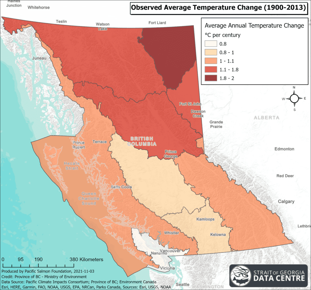
In BC, the greatest increases in air temperatures have occurred in the central and northern parts of the Province, as seen on the map on the left. Air temperatures in the Eastern and Southern Vancouver Island regions have been relatively stable in the past, but are expected to become warmer and possibly more variable into the future.
Summer heat waves like the record shattering ‘heat dome’ event that blanketed an extensive area of the Pacific Northwest for a week will become more frequent and intense, especially in lower elevations and valleys.
Equally important to extreme heat waves are relatively warmer winter night-time minimum temperatures. In coastal areas there will be fewer days that dip below freezing except at higher elevations, which will have implications for our snowpack and river flows.
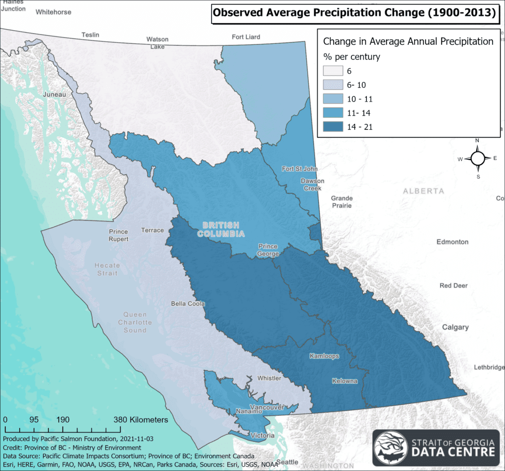
In the future it is projected that the cooler months will see more precipitation, but the summer will become drier. Already we are observing changes to precipitation as seen in the map, which shows an increase in average annual precipitation over the last 100+ years in BC, with the greatest increases being in the BC interior. The Georgia Depression has seen the greatest seasonal precipitation change with 23% increase during spring months. In winter, less precipitation will fall as snow due to warmer temperatures. This results in reduced snowpack in higher elevations and a loss of consistent melt waters that are so important to sustain streams through the dry season.
Increased precipitation in the fall and winter is likely to create more frequent high river flow and run-off events, particularly because less will fall as snow. This can cause overland flooding and erosion along rivers, which could threaten homes and other structures. Heavy winter rainfall also has the potential to destabilize slopes, which could trigger mass movement events like landslides, as well as lead to blockages of logs and other debris, causing rivers to overflow their banks. Higher flows will impact salmon habitats by lowering water clarity due to increased sediment inputs, scouring spawning gravel and threatening the stability of riparian vegetation that provide salmon shade, cooler waters and insect food sources. Stronger flows could potentially make migration much more difficult for Pacific salmon, and wash away salmon eggs from their redds (nests) in the gravel.
Sea Surface Temperature
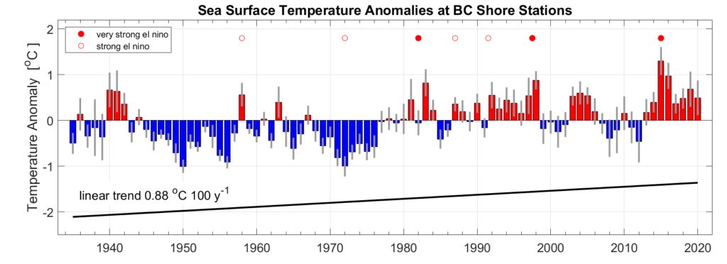
Long-term trends show that the sea surface temperatures have been increasing globally and the same is true along the BC coast. The rate of increasing sea surface temperature varies significantly by region around British Columbia. The increases have been most pronounced for the southern/inner coastal region where sea surface temperatures have been rising at a rate of 0.40°C per decade, whereas the temperatures in the northern/outer coastal region have been rising at 0.12°C per decade. If these trends continue, the sea surface temperatures in the Strait of Georgia may increase by 3°C by 2100.
Warmer sea surface temperatures from climate change on top of natural climate fluctuations increase the risk of events known as marine heat waves. During marine heatwaves, the thermal tolerances of marine species can be exceeded and result in stress or death. In the future, these are projected to increase in frequency, intensity, duration and spatial extent globally.
Warmer waters have been implicated in the loss of important habitats such as eelgrass meadows and kelp forests which are crucial to the life cycles of many species including salmon. Harmful algal blooms, biotoxins and disease outbreaks are also associated with warmer sea surface temperatures.
Ocean Acidification
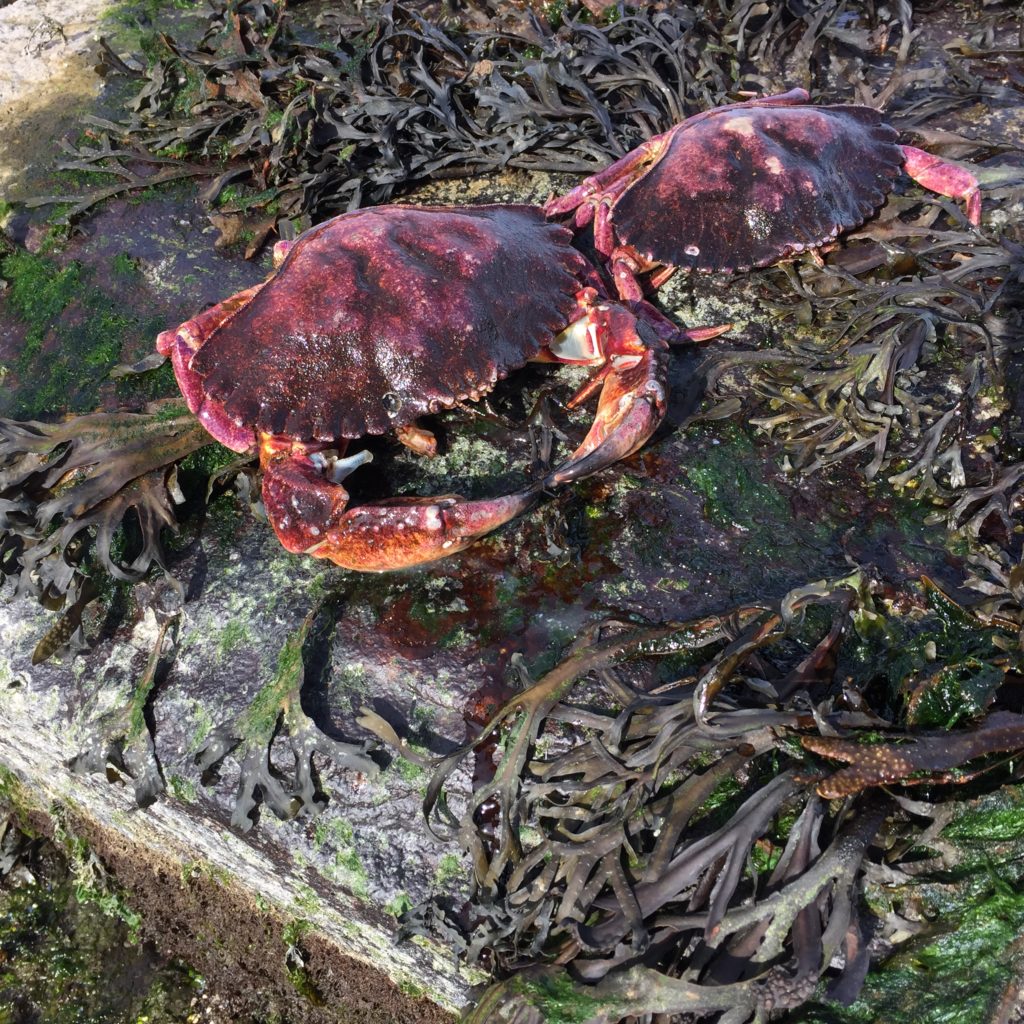
As part of the normal carbon cycle, ocean waters absorb a portion of CO2 from the atmosphere and this influences the pH of the water. With higher levels of CO2 in the atmosphere seawater is becoming more acidic. More acidic conditions make it more difficult for organisms that rely on calcium carbonate for their shells to form properly. This will challenge shellfish growers and many of our native shellfish species, including clams and crabs. Larval crab and other small crustaceans are vital to the food web and are an important food source for juvenile salmon!
Sea Level Rise
Sea level rise also varies by region due to a number of factors. In BC, sea level rise is projected to be greatest on the north coast, the Fraser Lowland and around southern Vancouver Island, ranging from 50 to 70cm by the year 2100 (median model change under RCP8.5; not accounting for the possibility of Greenland and Antarctic ice sheet disintegration). The rest of Vancouver Island is projected to experience a much smaller relative rise in sea level - mainly due to tectonic uplift. Generally sea levels have been rising at an accelerating rate as the oceans warm and ice sheet melt. Even at the modest end of this range, our coastlines as we know them will inevitably change.
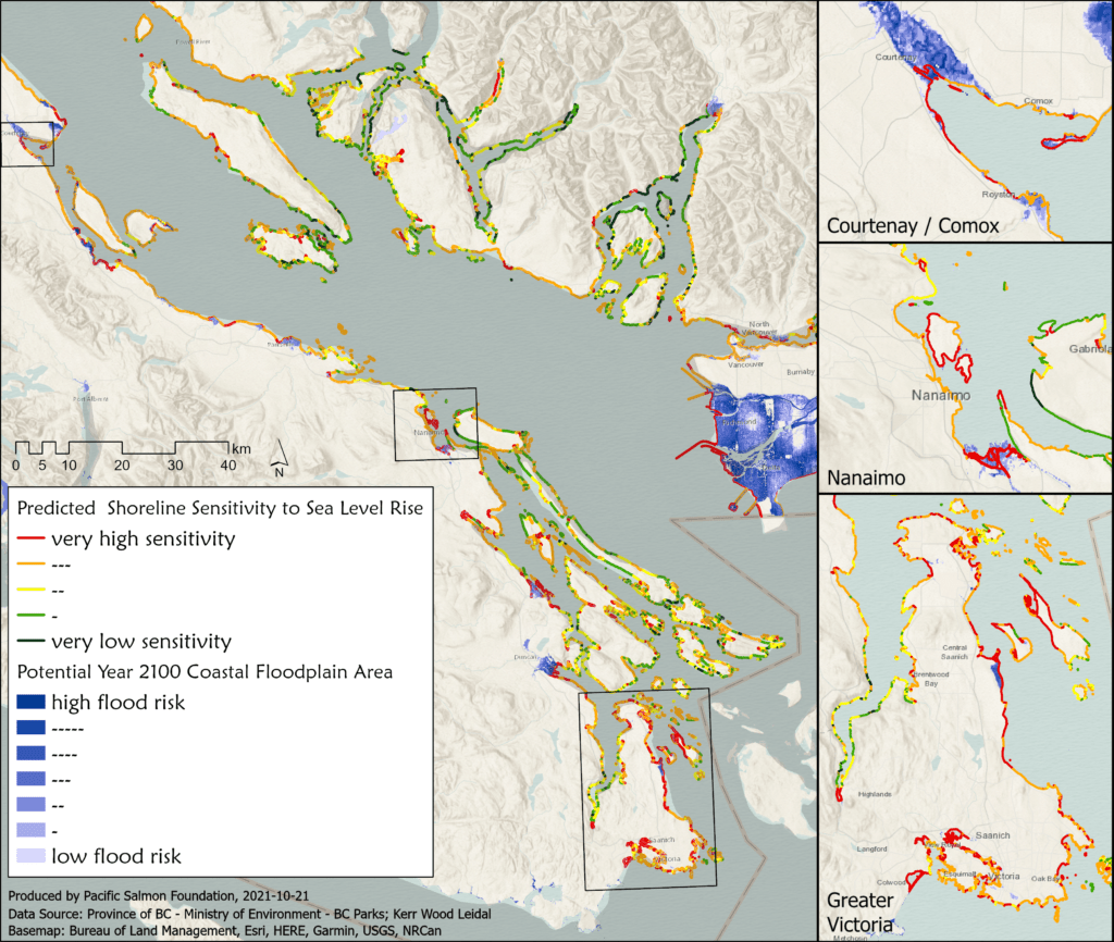
With higher sea levels and larger and more intense winter storms coming together, many areas of our coast will be at risk. Low-lying regions will experience more frequent flooding. By 2050, historical extreme flood events that occurred once per century, are projected to occurring on average at least once a year in many low-lying regions. Crashing waves hitting higher on the shoreline will cause increased erosion. Coastal bluffs will crumble at greater frequency than they had previously. Shorelines that have hard armour, like rip rap and seawalls, may be undercut causing them to fail. In many locations, accelerated erosion and flooding may damage culturally important places, threaten structures and impact intertidal habitats.
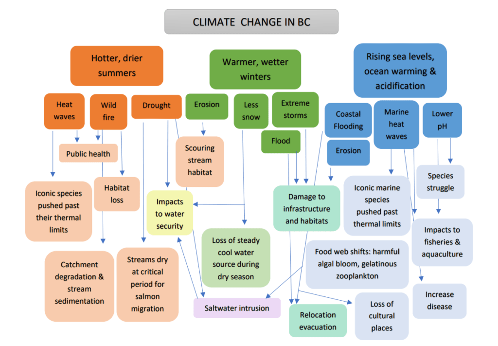
In sum, climate change will cause a myriad of challenges for British Columbians to adapt to. Depicted below are the projected changes expected for British Columbia and the cascading impacts that they will cause. Together these impacts may result in shifting ecosystems, where certain species may become locally extinct or conditions become more favourable for other species to become dominant; altered ways of life for communities such as relocation away from flood prone areas or redesigning homes and infrastructure to cope with extreme heat and storms; challenges for primary industries of forestry, agriculture, fisheries and aquaculture in light of the increases to wildfires, reduced water security during the growing season and warmer, more acidic seawater; and places of cultural significance may be lost or altered along with ways of life that have been practised in BC for millennia.
Learn more about the impacts of climate change and ways that BC can adapt in this Climate Change Backgrounder video made by the Province of BC.
And check out University of Victoria's Pacific Institute for Climate Solutions page.
Explore the tools on the Changing Coastlines web platform, including a visualization of climate change impacts on varying sectors under different coastal flooding scenarios. You can also find a backgrounder on practical strategies that can help us implement the ‘protect, retreat, accommodate, avoid’ approaches to coastal adaptation.
References for the information contained within this post:
Amos, C.L., Martino, S., Sutherland, T.F., and Al Rashidi, T. 2015. Sea Surface Temperature Trends in the Coastal Zone of British Columbia, Canada. Journal of Coastal Research 300: 434–446.
British Columbia Ministry of Environment (MOE). 2016. Indicators of Climate Change for British Columbia: 2016 Update. Ministry of Environment, British Columbia, Canada.
Capital Regional District (CRD). 2017. Climate Projections for the Capital Region.
IPCC. 2019. IPCC Special Report on the Ocean and Cryosphere in a Changing Climate. eds. Pörtner, H.O., Roberts, D.C., Masson-Delmotte, V., Zhai, P., Tignor, M., Poloczanska, E., Mintenbeck, K., Alegría, A., Nicolai, M., Okem, A. Petzold, J., Rama, B., and Weyer, N.M.
NOAA. 2017. Global and Regional Sea Level Rise Scenarios for the United States. NOAA Technical report NOS CO-OPS 083.
Oppenheimer, M., Glavovic, B.C., Hinkel, J., van de Wal, R., Magnan, A.K., Abd-Elgawad, A., Cai, R.,
Cifuentes-Jara, M., DeConto, R.M., Ghosh, T., Hay, J., Isla, F., Marzeion, B., Meyssignac, B., and Sebesvari, Z. 2019.
Sea Level Rise and Implications for Low-Lying Islands, Coasts and Communities. In: IPCC Special Report on the Ocean and Cryosphere in a Changing Climate. (Eds.) Pörtner, H.O., Roberts, D.C., Masson-Delmotte, V., Zhai, P., Tignor, M., Poloczanska, E., Mintenbeck, K., Alegría, A., Nicolai, M., Okem, A. Petzold, J., Rama, B., and Weyer, N.M.
Philip, S.Y., Kew, S.F., van Oldenborgh, G.J., Yang, W., Vecchi, G.A., Anslow, F.S., Li, S., Seneviratne, S.I., Luu, L.N., Arrighi, J., Singh, R., van Aalst, M., Hauser, M., Schumacher, D.L., Marghidan, C.P., Ebi, K.L., Bonnet, R., Vautard, R., Tradowsky, J., Coumou, D., Lehner, F., Wehner, M., Rodell, C., Stull, R., Howard, R., Gillett, N., and Otto, F.E.L. 2021. Rapid Attribution Analysis of the Extraordinary Heatwave on the Pacific Coast of the US and Canada June 2021. World Weather Attribution.
Photo credits: Jonathan Ford on Unsplash, Isobel Pearsall; Map Credit: Strait of Georgia Data Centre