Resilient Coasts for Salmon is part of the PSF
Marine Science Program
This includes the following features:
*collect beach access points only when they are officially built access pathways created by the municipality (do not include dirt paths created by foot traffic).
For anthropogenic debris, collect the following:
Receive survey link from the Resilient Coasts for Salmon team. When you press on the link, you can either open it within an App on your phone or through your phone’s web browser.
To install the App for ease of use:The Survey123 field app is available from Google Play, the App Store, and the Microsoft Store. You can install Survey123 directly onto your device from these stores.
When you open the application, it will provide you the option to sign up or to continue without signing in.
To download basemaps for offline use:
If you want to be able to map while offline, you can download offline basemaps to use while you’re in the field. You can download the maps while you are in range of the internet/wifi and follow these steps:
See HERE for step by step directions with photo examples.
Enter the start GPS coordinates into your GPS unit for the start point for the Shore Unit you are mapping. Follow to the correct location.
The following will be visuals from the app based output. This is what your screen may look like:

***If you do not know the Shore Unit # or it’s boundaries, please, please check out this web map showing ShoreZone unit lines. As long as you have internet access, you can pull it up in your phone’s browser to see your location and the corresponding unit line.
Now, please check the top of the page for any available updates for the surveys. If there are, download them as follows:
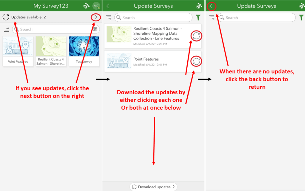
After opening the App, checking for updates and loading basemaps if desired, select the survey of interest. Once you have, this is what your page should look like.
Press the “Collect” button (circled in red) to start your survey.

Once the survey loads, please read over the instructions.“Collect point feature data for specific modifications along the shoreline.”
Follow steps in order of sequence.
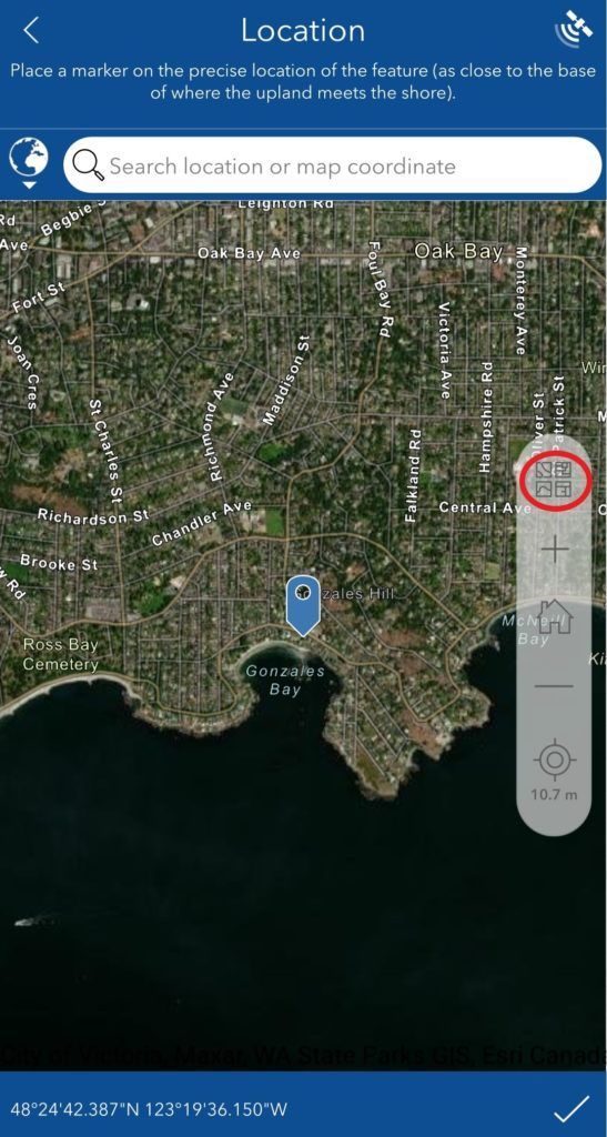
Place the location of the feature as close to the base of where the upland meets the shore. See an example below for the placement of the red dot.

Follow the prompts/questions as they appear in order.
The Date and Time will automatically be entered with each submission.
New questions/prompts will appear as you fill out the survey. Please follow them in order as they appear.
How to create point features. Click the map icon. Zoom in to desired area. Use the Imagery Hybrid option for clear viewing (as shown here). Your screen should look like this. Place the location of the feature as close to the base of where the upland meets the shore.

Press the check mark on the bottom right of the screen, then your screen should look like this:

Press the check mark at the bottom right of the screen once you are done the full survey. This is what your screen should look like. A pop-up will appear called “Survey Completed” as depicted below. Please select either “Send now” if you have good wifi range or select “Save in Outbox” if you would prefer to send it once you are home with better internet service. Don’t forget it’s in your Outbox!
You can select “Continue this survey” if you have prematurely pressed submit by mistake.

Cook, S., Daley, S., Morrow, K., and S. Ward. 2017. ShoreZone Coastal Imaging and Habitat Mapping Protocol. Coastal and Ocean Resources.
MacLennan, A., Johannessen, J., and A. Lubeck. 2018. Armor Mapping Methods for the Puget Sound Region.
Friends of the San Juans. San Juan County Shoreline Mapping Project 2019. Courtesy of Tina Whitman.
SeaChange Marine Conservation Society. 2020. SIPAS (Saanich Inlet and Peninsula Atlas of Shorelines) 2020 Technical Report - Draft 3.